Wheel of Time Map

A detailed, interactive map of the Westlands. Search any place, follow the Book 1 journeys and hide spoilers by book.

Skip the map
CairhienTearIllianAndorTwo RiversSaldaeaKandorArafelShienarArad DomanTarabonAmadiciaGhealdanAltaraMurandyToman HeadAlmoth PlainCaralain GrassAiel WasteThe BlightMountains of MistSpine of the WorldHaddon MirkPlains of MaredoSeanchan

What you can do with this map

The nations of the Westlands

Fifteen nations, the city-states of Tar Valon and Far Madding, and several empty lands share the continent between the Aryth Ocean and the Spine of the World.

Locations

The first journey, step by step

Three groups leave Emond's Field on Winternight, scatter at Shadar Logoth and meet again in Caemlyn before the Ways carry them north to Fal Dara.

See the Book 1 routes
Painted Wheel of Time map of the world showing the Westlands, the Aiel Waste, Shara and the Seanchan Empire

Beyond the Westlands

Most of the story happens in the Westlands, but the world is much bigger: the Aiel Waste, secretive Shara, the Seanchan Empire across the ocean and the Mad Lands to the south.

Explore the whole world

A complete guide to the Wheel of Time map

Robert Jordan's The Wheel of Time runs to fourteen novels and a prequel, and its heroes cover thousands of miles. Almost every reader ends up flipping back to the map at the front of the book. This site turns that map into an interactive Wheel of Time map you can search, zoom and share.

It covers the Westlands, where most of the story happens, and links to a separate map of the wider world. Everything is free, needs no account and works on a phone as well as on a desktop.

What the Wheel of Time map shows

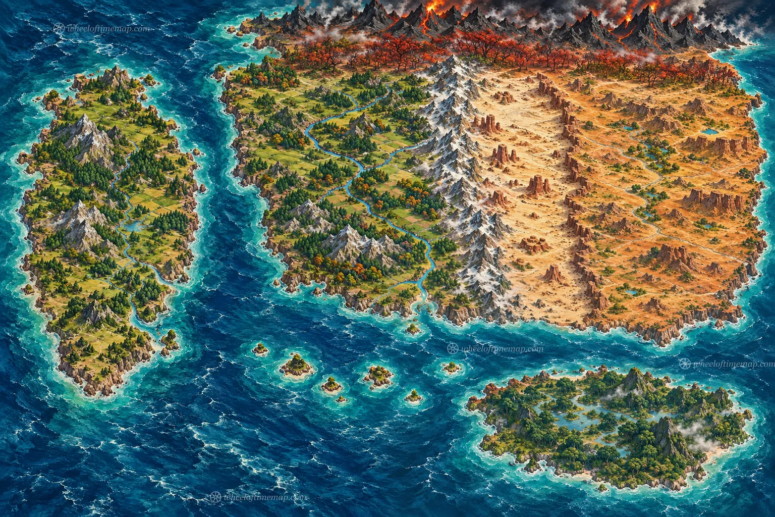
The main map shows the Westlands, which fans often call Randland after Rand al'Thor. It runs from the Aryth Ocean in the west to the Spine of the World in the east, and from the Blight in the north to the Sea of Storms in the south. In between lie the great rivers, the Mountains of Mist, the forests and the plains where the nations of the story rise and fall.

On top of the painted artwork sit 58 named places. There are capital cities such as Caemlyn, Tar Valon, Cairhien and Tear, villages such as Emond's Field and Baerlon, ruins such as Shadar Logoth, and landmarks like the Eye of the World and Shayol Ghul. Each one opens a short guide in the side panel and has its own page with more detail and a link back to its spot on the map.

How to use the interactive map

Type a name into the search box and the map flies straight to it. Drag to pan, pinch or scroll to zoom, or use the keyboard if you prefer. The list on the left shows or hides cities, landmarks, nations and regions, so a busy view can be cut down to the places you care about. The ruler measures the distance between any two points in miles and kilometres, and every place has a link you can copy to send a friend directly to it.

The spoiler filter is the feature readers ask for most. Choose the last book you have finished and places that only matter later stay hidden until you reach them. If this is your first read, set it to The Eye of the World and the map stays safe.

A detailed, high resolution map

The artwork is an original painting made for this site, not a scan of a printed page. It is served as a set of sharp image tiles, so you can zoom from the whole continent down to a single bend in a river while the picture stays crisp, and only the part you are looking at is downloaded. That keeps the high resolution Wheel of Time map fast even on a mobile connection.

Place names are drawn by the browser instead of being baked into the picture. They stay readable at every zoom level, adapt to light and dark mode, and appear in all eight languages of the site.

Nations, borders and Randland politics

Many readers look for a Wheel of Time map with borders. The trouble is that the borders move a great deal over the series. Andor's claims, the Seanchan conquests in Tarabon and Altara and the wars in Cairhien all redraw the political map from one book to the next.

Rather than freezing one moment in time, this map places each nation's name over its heartland and links it to a guide that explains how its lands change as the story goes on. Start with the guides to Andor, Cairhien, Tear, Illian, Altara, Tarabon, Saldaea and Shienar.

The Wheel of Time map for Book 1

For new readers, the Book 1 view is the most useful. The journeys page follows each group out of Emond's Field on Winternight. Rand and Mat travel by riverboat and on foot through Whitebridge. Perrin and Egwene cross the open country with Elyas and the Tinkers. Moiraine, Lan and Nynaeve follow their trail.

All three paths meet in Caemlyn. From there the Ways carry the whole group north to Fal Dara, and the last chapters take them into the Blight. Seeing the routes side by side makes it much easier to follow the story when the chapters jump between characters.

The Wheel of Time map of the world

The Westlands are only one part of the world. The separate world map shows the Aiel Waste beyond the Spine of the World, the closed land of Shara, the Seanchan Empire across the Aryth Ocean, the Sea Folk islands and the unexplored Mad Lands in the far south.

The books describe these lands in far less detail, so the world map is simpler. Even so, it shows how the whole world fits together and where the Westlands sit inside it, which helps a lot in the later books when the Seanchan arrive and the Aiel cross the Dragonwall.

PDF, poster and 4K versions

This map is made for viewing in a browser, so there is no PDF or 4K file to download. Zooming in on the interactive map is the best way to see the artwork at full resolution.

If you want a Wheel of Time map poster for your wall, look for the official maps by Ellisa Mitchell. They are printed in the novels and in companion books such as The World of Robert Jordan's The Wheel of Time. For reading notes, fan wikis or a tabletop game, you are welcome to use screenshots of this map for personal, non-commercial projects.
How this map was made

This is an original, fan-made illustration. The coastlines, mountains, forests and rivers were drawn from the descriptions in Robert Jordan's books and the well-known shape of the published maps, then placed on a single scale.

Positions are faithful to the story but approximate. Distances use a common estimate that Andor is about 1,700 miles wide, so treat them as a guide for readers rather than survey data.

Wheel of Time map: common questions

What is the Wheel of Time map called?

The Wheel of Time map in the books shows the Westlands, the part of the continent between the Aryth Ocean and the Spine of the World where most of the story happens. Fans often call the whole continent Randland, after Rand al'Thor.

Is there an interactive Wheel of Time map?

Yes. This site is a free interactive Wheel of Time map. You can search 58 places, zoom into any region, measure distances, follow the Book 1 journeys and hide spoilers by book, on a phone or a computer, in eight languages.

Who drew the original Wheel of Time map?

The Westlands map printed in the novels was drawn by Ellisa Mitchell. A larger world map appeared in the 1997 companion book The World of Robert Jordan's The Wheel of Time, and Mitchell drew an updated world map for Origins of The Wheel of Time. The map on this site is an original illustration made for fans.

Is there a high resolution Wheel of Time map?

The painted map on this site is served as zoomable image tiles, so it stays sharp from the full continent down to a single city. Open the map and zoom in to see the artwork at its highest resolution.

How big are the Westlands?

Robert Jordan never published an official scale. A common estimate puts Andor at about 1,700 miles from the Mountains of Mist to the Erinin, which makes the Westlands roughly 4,000 miles from the Aryth Ocean to the Spine of the World.

Does the map show the borders of each nation?

Borders change a lot over the fourteen books, so the map shows each nation's name over its heartland instead of fixed lines. Each nation's guide explains how its territory shifts during the series.

Where does The Eye of the World take place?

The first book starts in Emond's Field in the Two Rivers, moves through Baerlon, Shadar Logoth, Whitebridge and Caemlyn, then jumps through the Ways to Fal Dara in Shienar and ends in the Blight at the Eye of the World.

Is there a map of the whole Wheel of Time world?

Yes. The world map shows the Westlands together with the Aiel Waste, Shara, the Seanchan Empire, the Sea Folk islands, the Mad Lands and the Blight, so you can see how the whole world fits together.

Does this map contain spoilers?

Place names on their own reveal very little, but some summaries mention events. Use the spoiler filter to choose the last book you have finished, and later locations are hidden on the map.

Is the TV series map different from the books?

The Prime Video series uses the same geography as the novels, including Andor, Tar Valon, the Two Rivers and the Aiel Waste. Some events happen in different places or in a different order than in the books, so use the book filter if you are following the novels.

Is there a Wheel of Time map PDF or poster?

This site does not offer a PDF or a printable file. For a poster, look for the official Ellisa Mitchell maps, which appear in the novels and in companion books. Screenshots of this map are fine for personal, non-commercial use.

Can I use this map?

You are welcome to use screenshots of the map for personal, non-commercial projects such as reading notes, fan wikis or tabletop games. A link back to wheeloftimemap.com is appreciated.